First off, before we go further a freight train sized THANK YOU to NYSDOT for their dedication and response to public input on this project. The agency deserves kudos for the inclusion of the walkway into the project.
NYSDOT has scheduled two public hearings on the the Environmental Assessment for the Bridge replacement that the public can be a part of!
May 31, 2022 at 6:00 PM Virtual Information Meeting and Hearing
Attend this virtual event through Zoom at the following link: https://us06web.zoom.us/j/88482381382
Phone number: 646 558 8656
Webinar ID: 884 8238 1382
June 1, 2022 at 6:00 PM In-Person Informational Meeting and Hearing
Attend this In-Person event at The Palace Theater (19 Clinton Ave, Albany, NY 12207)
From the project’s Environmental Assessment:
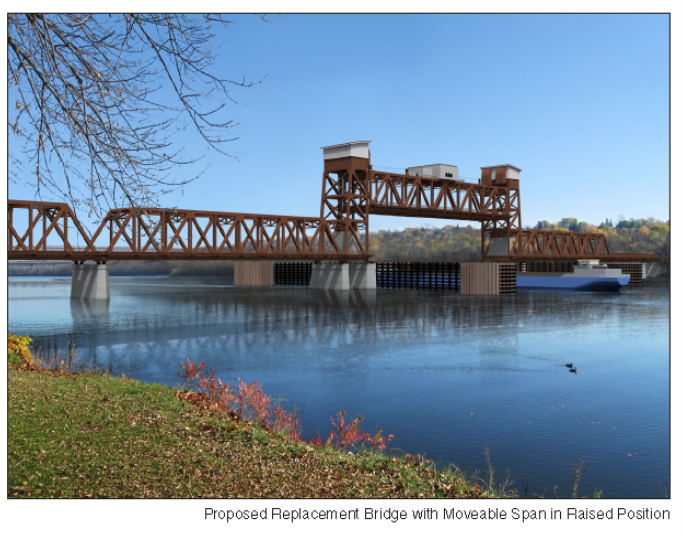
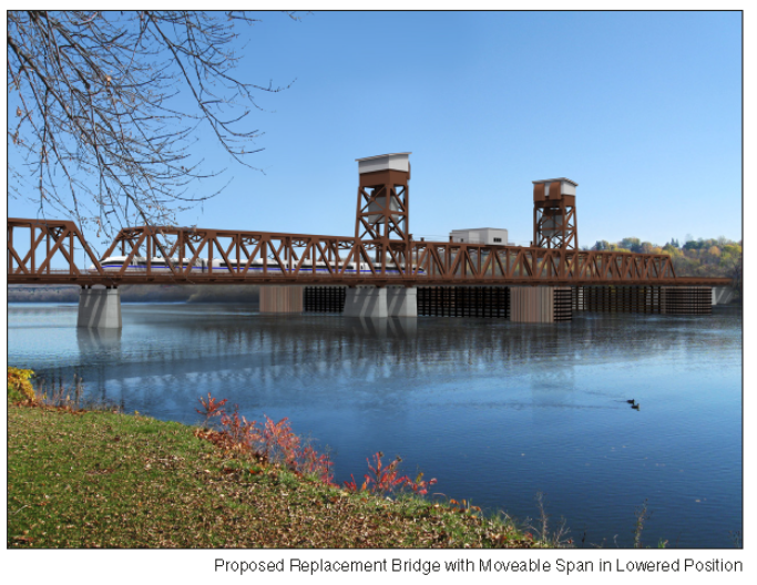
“2.4.2.9 Shared Use Path – Both Build Alternatives would include a new shared use path for pedestrians and bicyclists. FRA and NYSDOT evaluated a range of different configurations for the shared use path for each Build Alternative and selected the design options described below. For both Build Alternatives, the shared use path would run along the south side of the new bridge on a cantilever extending from the bridge trusses and supported on an independent girder superstructure parallel to the rail girder spans that shares piers and abutments with the deck girder approach spans of the rail bridge. The shared use path would be 12 feet wide on the bridge to allow two-way pedestrian and bicycle traffic, and would widen to 14 feet at the base of its approaches. The approach ramps would have a grade of no more than 5 percent and the shared use path and its approach ramps would comply with the Americans with Disabilities Act (ADA). The approach ramps for the shared use path would touch down south of the new bridge and connect to existing and planned waterfront pathways on each side of the river. On the east side of the river, the shared use path would connect to the planned Rensselaer Riverfront Multi-Use Trail, a linear park that will run along the waterfront. On the west side of the river, it would connect to the Mohawk-Hudson Bike-Hike Trail, which runs along the waterfront, and the Albany Skyway (see the discussion in Section 3.3.3). Both Build Alternatives would have a retaining wall along the south side of the railroad embankment in Albany between the river and Water Street to support the sloping shared use path. The retaining wall would be designed to be visually compatible with the existing landscape. The shared use path would have a bicycle height railing on the outboard side and a pedestrian security fence and bicycle height railing on the inboard side to prevent unauthorized access from the walkway onto the railroad tracks. The walkway would include scenic overlooks at each end of the movable span to provide an area for pedestrians to collect and bicyclists to dismount when the bridge is opening/closing and the walkway gates are closed. Lighting, cameras, and other security devices would ensure safe operation of the movable bridge span. NYSDOT will coordinate details related to operation and maintenance of the shared use path on the bridge during final design. NYSDOT has ongoing coordination with the Cities of Rensselaer and Albany as well as CSX and Amtrak regarding ownership and maintenance of the shared use path.”
This is wonderful news but one has to wonder if it wouldn’t be more cost effective to eliminate the need for the retaining wall and ramp to allow for a direct connection to the Skyway that lies roughly 24 ft. to the south of the current walkway.
“Where can I read more,” you must be asking. Well click the link and surf on over to https://www.dot.ny.gov/display/projects/livingstonavebridge
There’s 1000s of pages of god stuff – from an existing conditions report to environmental impact assessments and design alternative considerations. Oh joy!
And there are renderings!